Wildfire Information
Polis declares statewide drought emergency as Colorado enters Phase 3
Read the full article here:
Polis declares statewide drought emergency as Colorado enters Phase 3


Defensible space for your home
.webp?ixlib=rb-1.1.0&w=2000&h=2000&fit=max&or=0&s=be81ed1d3a51e61076266fcc63b5a4dc)
We will assess and make recommendations during our wildfire risk assessment inspection how to improve the defensible space around your home
Memorandum for Property Insurance Carrier

Once wildfire assessment is complete you will receive the risk assessment worksheet as well as an official memorandum to give your insurance company
Ladder fuels mitigation
.webp?ixlib=rb-1.1.0&w=2000&h=2000&fit=max&or=0&s=109bf6e89d2ffad89dcc311732c5474d)
We will assess and make recommendations on ladder fuels and how to improve your fuel mitigation work.
Contact to schedule wildfire risk assessment
Photo Gallery
.webp?ixlib=rb-1.1.0&w=2000&h=2000&fit=max&or=0&s=50f3181976cad3060ed90b8ef1c1ccbd)
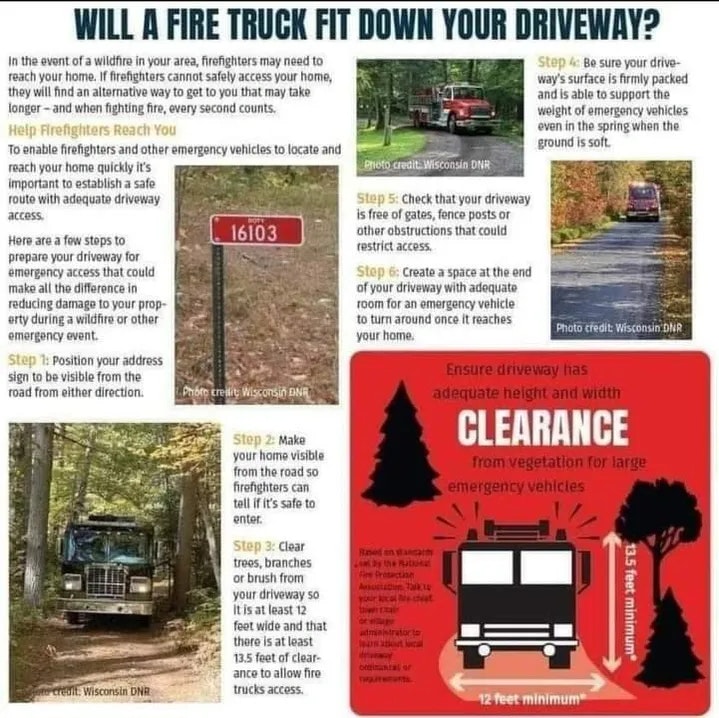
Plan ahead to help the fire department navigate your driveway!